|
|
|
|
|
|
 |
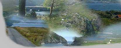
The Beara Peninsula |
|
The
Beara Peninsula offers some spectacular scenery and wonderful
walks. The peninsula is remote with bleak moorland and
sparsely populated fishing villages. |
|
Route Details : 147Km
(90miles) |
|
Road Type : Normal |
|
View More Pictures... |
|
|
|
|
-
At the Western end of Glengariff, the roads divides
into two; select the road on the left (R572)
-
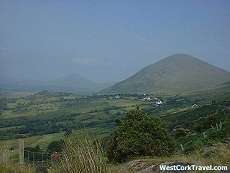
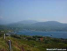
As you drive towards Adrigole, you will get various
views of Bantry Bay on your left, on your right is the Sugarloaf
Mountain, part of the Caha Range. Beyond the village of Adrigole
go right at the sign for the Heally Pass (R574).
-
To your left as you climb you will see Hungry Hill,
also part of the Caha range which divides county Cork from County
Kerry.
|
 |
 |
-
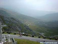
The highest Waterfall in Ireland is
Located on Hungry Hill.
-
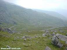
The Healy Pass, which rises 334
meters above sea level. It is named after a Bantry man, Tim
Healy, the first Governor-General of the Irish Free State.
-
Pause at the summit to view the
scenery on both sides
|
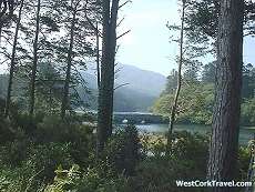
-
As you begin your descent, Glanmore Lake is a
picturesque valley down to your left.
-
At the end of your descent, follow the "Ring of Beara"
sign in the direction of Castletownbere. (R571).
-
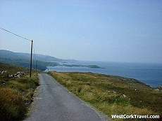
At Ardgroom - a pleasant village with good trout
fishing in nearby lakes - leave R571 and follow the "Ring of Beara "
sign to your right. Parts of this road are quite narrow but the
views are breathtaking as you skirt along the shore of Kenmare Bay.
The peninsula you see across is the Iveragh Peninsula, note for its
ring of Kerry route.
|
 |
 |
-
You rejoin R571 before you reach
Eyeries. (If in doubt at any stage of the route, follow the
"Ring of Beara" signs). Eyeries is noted for its colour & its
floral displays. Shore angling is very popular here. The
TV series 'Falling for a Dancer', starring Colin Farrell, was shot here.
-
Beyond Eyeries take the R575 to
Allihies for another change of scenery. Allihies looks out to
sea and is surrounded on the other three sides by the Sliabh Miskish
Mountains. It was for centuries a centre of copper-mining.
Daphne du Maurier's novel 'Hungry Hill' is set in this area, in the
copper-mining era. Signs of former mining activity is still
evident.
|
-
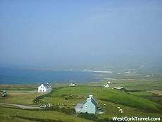
As you cross the "toe" of the peninsula to get to the
Bantry Bay side, it is worth the effort to got right on R572 to Dursey
(R572 is a cu-de-sac). Here Irelands only cable-car operates.
You may even be tempted to take the cable-car to Dursey Island,
famous for its variety of bird life.
-
Note also the Millennium Sundial which marks the spot
where the last European sunset of 1999 was celebrated at 4.41p.m. on
December 31st.
-
We now rejoin the main road (which becomes R572) and we
begin our return journey to Glengarriff by the southern edge of the
peninsula.
|
 |
-
Shortly before you reach
Castletownbere, a signpost to your right indicates the way to Dunboy
Castle. This was the stronghold of the O'Sullivan Beare.
In 1602, this was the scene of a siege and a massacre which ended
the local sovereignty of O'Sullivan Beare and the remnant of his
clan on a midwinter epic march to Leitrim. Of the thousand
people who left Glengarriff, only thirty nine reached Leitrim.
Few traces of the castle remain. The later ruins are of an
elaborate nineteenth century edifice built by the Puxley Family,
copper-barons, who were landlords here.
-
Castletownbere (or
Castletownbearhaven) is now one of Irelands main fishing ports.
It is the second largest natural port in the world and is the
largest whitefish port in Ireland. The "Call of the Sea
Centre" on the north road is well worth a visit, if you wish to
deepen your knowledge and appreciation of the peninsula.
-
We now leave Castletownbere and as we
drove towards Adrigole we can view "Hungry Hill" from another angle
and then our journey takes up past the Sugarloaf Mountain again as
we return to Glengarriff and the end of our 147km tour.
|
|
|
|
|
|
Copyright © A MC. All rights reserved
Terms Of Use |