|
|
|
|
|
|
 |
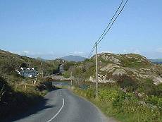
The Mizen Head
|
|
Enjoy some of the most stunning views as
you drive to Irelands most southerly point. |
|
Route
Details : 147Km |
|
Road Type : Normal |
|
View More Pictures... |
|
|
-
The journey begins on the R592 from the Market town of
Skibbereen. One takes the detour route through the town, via
Townsend Street, and follow the Ilen river along the route to
Ballydehob. This refreshing country route leads to Church Cross,
where the view becomes more charming at the lay-by outside Ballydehob.
The sea broadens and Kilcoe castle a rusty painted edifice is
gloriously reflected in the water.
-
As you enter this village from the east, the
twelve-arched bridge to your left dominates the skyline. This
bridge beside the children's playground, was part of the West Cork
Tramway, which ceased to operate in 1947.
|
 |
 |
-
Ballydehob is the native village of
Dan O'Mahony, who was world wrestling champion in the 1930's.
To continue one's journey to Schull one chooses the road to the
right up past this champion's statue.
-
Schull is a
cosmopolitan village, where various nationalities merge and interact
outside it's pubs and cafe's. Schull can also boast of one of
the finest harbours in the south-west coast. A favourite port
of yachtsmen, Schull has also the only planetarium in the republic.
-
Trips to Cape Clear Island can also
be availed of from here, but let's not forget that we are continuing
to Mizen Head.
|
-
On the way to Schull, Mount Gabriel (1339 feet)
dominates the peninsula. The two huge globes on the summit are
part of a European wide air and sea traffic monitoring system.
Mount Gabriel had the oldest worked copper mines in north-west Europe
dating back to the 17th century B.C.
-
We head on into the colourful rugged village of Goleen,
via the Coast route, which is the first hill road on the left as one
bids farewell to Schull.
-
As one climbs, no camera could caputre the magnificence
of the view as on one's right one overlooks patchworks of grassland
with cattle grazing, rocks and trees, interlayered between the azure
of the ocean which stretches to the horizon.
|
 |
 |
-
When one descends from this
intoxicating vista, one rejoins and turns left on the main level
road from Schull to Goleen. The flora along this roadside is
pretty impressive with reeds, bracken, gorse, daisies ragwort etc.
-
The rushy lakeside outside the
hillside village of Goleen is a pleasant sight. One can visit
Ballyrisade Strand from here or continue and regain one's breath in
the village.
-
A tree enshrouded aged Church of
Ireland church lies slightly on a height on one's right as one
leaves Goleen to hug the coast all the way to the Mizen.
|
-
There is a cul de sac leading to watch towers and a
former coastguard station on one's left, or meander on right past
dappled rocks and look across at the fabulous yachting habour of
Crookhaven. This picturesque village was chosen for some of the
scenes in "I thank a fool" starring Peter Finch and Susan Hayward.
-
Nor far from the village Marconi sent his first radio
message to America. The ruined station is still visible.
|
 |
-
Keeping to one's right one passes by
the golden sandy beach at Barleycove. Then one chooses a high
road to the left, to follow along the high-cliffed peninsula,
majestically carved and sculptured by the Atlantic ocean. Here
one reaches the wide car park at the Mizen Head the most south
westerly point in Ireland. since, 1993, the old light house
has been develooped as a project known as Mizen Vision. A
visitors centre provides on with historical and local information.
-
On a fine day the Fastnet
Lighthouse can be seen across the way in the middle of the ocean.
-
While a path past the visitors centre
leads to the lighthouse, one must behave in a responsible manner
when descending the 99 steps that lead to the white bridge which
crosses the rocky chasm to the lighthouse. Be particularly
vigilant with children especially in blustery weather, but otherwise
enjoy the spectacular views.
|
|
|
|
|
|
Copyright © MC. All rights reserved
Terms Of Use |
|
| |
| |
|
Accommodation |
|
's
Cottages |
|
|
|
|
|
|